
Hiking & Backpacking Rio Blanco County
Rio Blanco County is northwest Colorado’s premier destination for hikers and backpackers who want to escape the crowded resort tracks of the central Rockies. Centered around the authentic ranching hub of Meeker and stretching west toward Rangely, the county is defined by unique geological wonders: high volcanic plateaus, sheer sandstone cliffs, subalpine alpine lakes, and hidden river canyons.
With the massive White River National Forest and the legendary Flat Tops Wilderness right in its backyard, Rio Blanco County offers an unmatched, uncrowded playground spanning hundreds of miles of pristine wilderness.
The Premier Hiking Regions
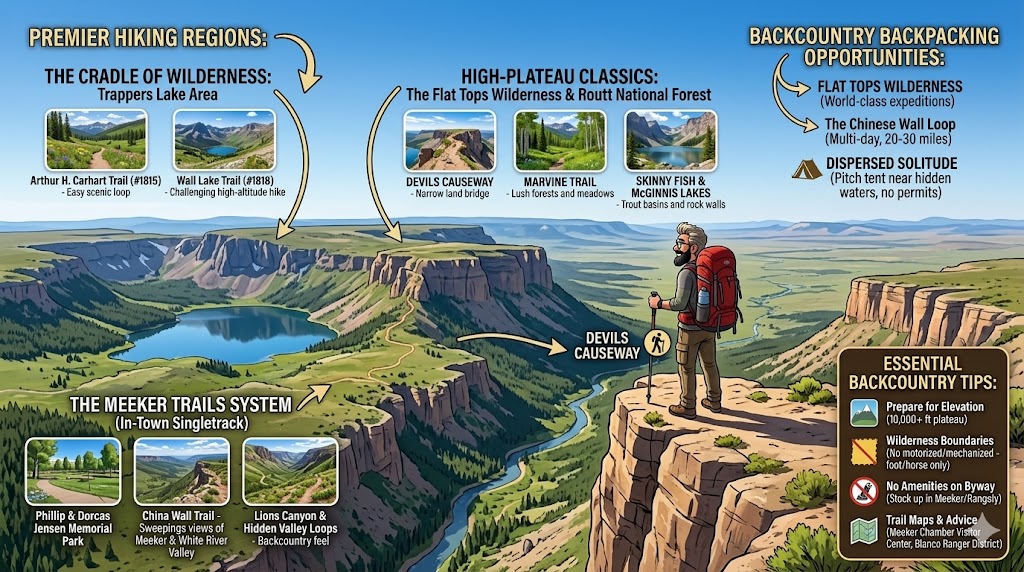
1. The Cradle of Wilderness: Trappers Lake Area
Nicknamed the “cradle of the wilderness” for its role in inspiring the American Wilderness Act, Trappers Lake sits roughly 50 miles east of Meeker. It is framed by towering volcanic cliffs and serves as a major gateway into the high-plateau country.
Arthur H. Carhart Trail (#1815): An easy, highly scenic 5-mile loop that circles the pristine shoreline of Trappers Lake. It offers spectacular, panoramic views of the water mirroring the sheer basalt cliffs above.
Wall Lake Trail (#1818): For a more challenging day hike, this trail provides the most direct route up onto the massive Flat Tops plateau, climbing past fields of alpine wildflowers to a stunning high-altitude lake.
2. High-Plateau Classics: The Flat Tops Wilderness & Routt National Forest
The Flat Tops are characterized by flat-topped volcanic tables, sprawling tundra, and alpine bowls.
Devils Causeway: Accessible from trail networks cutting into the wilderness, this is one of Colorado’s most famous “thrill-seeker” hikes. The trail leads to a narrow, 100-foot-long land bridge that shrinks to just 3 to 4 feet wide, flanked by vertical drops on both sides.
Marvine Trail: This popular route tracks Marvine Creek through lush subalpine forests, open meadows, and narrow valleys, dead-ending at the pristine Marvine Lakes. It is excellent for spotting wildlife like elk and mule deer.
Skinny Fish & McGinnis Lakes: A moderate 7.8-kilometer round-trip hike that rewards adventurers with views of steep rock walls wrapping around two quiet, trout-rich alpine basins.
3. The Meeker Trails System (In-Town Convenience)
You don’t have to drive deep into the mountains to find premium singletrack. Directly bordering the town of Meeker, the Phillip & Dorcas Jensen Memorial Park holds a 57-acre trail system.
China Wall Trail: A steep but smooth singletrack that switchbacks up the northern bluffs. Resting at the 1.5-mile summit bench treats hikers to spectacular, sweeping views of Meeker and the White River Valley.
Lions Canyon & Hidden Valley Loops: Rugged, flowy backcountry loops that showcase side-slope singletrack and beautiful, rocky terrain perfect for a quick morning trek.
Backcountry Backpacking Opportunities
As Colorado’s second-largest wilderness area, the Flat Tops Wilderness contains over 160 miles of trails and 110 lakes, making it a world-class destination for multi-day, self-contained backpacking expeditions.
The Chinese Wall Loop: Backpackers can string together the South Fork, Lost Solar, and Chinese Wall trails for epic, multi-day loops ranging from 20 to over 30 miles. You will hike across alpine tundra averaging 10,000 feet in elevation, camping under some of the darkest, starriest skies in the state.
Dispersed Solitude: Unlike the highly restricted permit systems of the Front Range, backpacking here allows for authentic, dispersed wilderness camping. You can pitch your tent near hidden waters like Pagoda Lake, Ute Lake, or the Mandall Lakes, often without seeing another soul for days.
Essential Tips for the Rio Blanco Backcountry
Prepare for Elevation: The Flat Tops plateau averages over 10,000 feet in elevation. Give yourself a day to acclimate in Meeker (6,240 feet) before pushing into the high backcountry to avoid altitude sickness.
Wilderness Boundaries: Motorized vehicles and bicycles are strictly prohibited within the Flat Tops Wilderness boundaries. Mechanized items (including game carts) are also banned—it is pure foot and horseback travel only.
No Amenities on the Byway: If you are accessing the trailheads via the gorgeous Flat Tops Trail Scenic Byway, remember that there are zero gas stations or convenience stores along the 82-mile mountain road. Fuel up and stock up on trail snacks in Meeker or Rangely before heading out.
Trail Maps & Advice: Stop by the Meeker Chamber of Commerce Visitor Center on Market Street to pick up local topographic trail maps and get real-time trail conditions from the Blanco Ranger District office