Hiking & Backpacking Moffat County
Moffat County is Colorado’s ultimate frontier for hikers and backpackers who favor rugged solitude over crowded, resort-heavy trails. Spanning nearly 4.8 million acres, the county transitions from alpine mountains to deep river canyons and arid high-desert badlands.
Whether you are looking for an easy morning rim walk or an intense multi-day backpacking trek through untouched wilderness, Moffat County delivers a raw, crowd-free outdoor experience.
The Premier Hiking Regions
1. Dinosaur National Monument (Colorado Side)
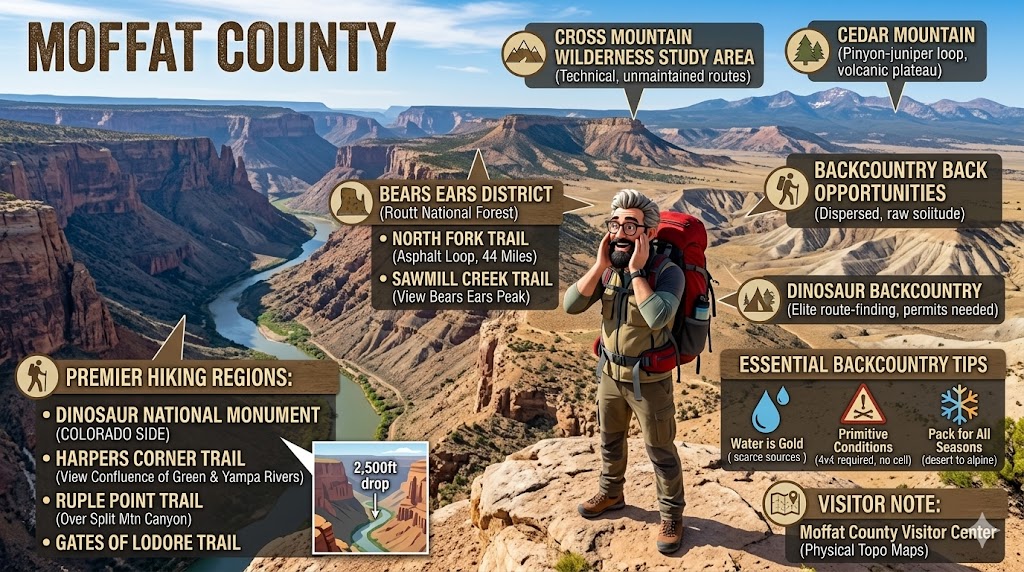
While the famous fossil quarry sits just across the border in Utah, the vast majority of the monument’s dramatic canyon country lies in Moffat County. This area offers some of the most geologically striking rim and canyon hikes in the American West.
Harpers Corner Trail: An absolute must-do. This easy-to-moderate 2-mile round-trip trail follows a narrow ridge line, ending at a breathtaking viewpoint that peers 2,500 feet down into the confluence of the Green and Yampa rivers.
Ruple Point Trail: For a longer day hike, this 9.2-mile round-trip journey takes you across high-desert pastures before dead-ending at a sheer cliff edge overlooking the dramatic Split Mountain Canyon.
Gates of Lodore Trail: A short, scenic 1-mile path at the northern tip of the county that leads you to the majestic maw where the Green River slices into towering, deep-red sandstone canyon walls.
2. Bears Ears District (Routt National Forest)
If you want classic Colorado alpine scenery—think dense aspen groves, dark pine forests, and cool mountain streams—head north of Craig into the Elkhead Mountains.
North Fork Trail: This expansive, 44-mile trail network follows Elkhead Creek and can be coupled with the Bears Ears and Sawmill Creek trails to form a spectacular 13-mile loop. It is highly regarded for its vibrant wildflowers in July and brilliant gold aspens in September.
Sawmill Creek Trail: A 3.6-mile hike that closely tracks Sawmill Creek, rewarding hikers with one of the most iconic, uninhibited views of Bears Ears Peak.
3. Cross Mountain Wilderness Study Area
For experienced hikers looking to step completely off the grid, Cross Mountain is a massive, structural wave of rock rising out of the sagebrush desert.
The Cross Mountain Rims: There are no highly developed, manicured trails here; instead, hikers navigate rugged, unmaintained routes to the north and south rims. Standing on the rim offers a dizzying view straight down into the technical, roaring whitewater of Cross Mountain Gorge.
4. Cedar Mountain (Local Favorite)
Located just a few minutes north of Craig, Cedar Mountain is the go-to spot for locals looking for a quick, high-reward workout.
The Loop: A moderate 3.5-mile loop trail winds through pinyon-juniper woodlands up to a flat-topped volcanic plateau. The summit delivers panoramic views of the Yampa River Valley, Craig, and the distant peaks of Steamboat Springs.
Backcountry Backpacking Opportunities
Moffat County is uniquely suited for dispersed, backcountry backpacking, particularly across the vast Bureau of Land Management (BLM) lands like the Little Yampa Canyon and Duffy Mountain areas.
Wilderness Backpacking: Unlike heavily regulated national parks, much of Moffat County’s BLM land allows you to pack in, map your own route, and camp under some of the darkest night skies in the nation.
Dinosaur Backcountry: True wilderness backpackers can secure backcountry permits from the National Park Service to trek deep into areas like Echo Park or the Yampa Bench. Navigating these arid, deep-canyon microclimates requires elite route-finding skills, as established trails quickly give way to wild game paths.
Essential Tips for the Moffat Backcountry
Water is Gold: Moffat County is largely high-desert terrain. Natural, clean water sources are incredibly scarce outside of the main river corridors. Backpackers must be prepared to pack in all their water or carry heavy-duty filtration systems capable of handling highly silty river water.
Primitive Conditions: Many trailheads require high-clearance 4×4 vehicles to reach, and cell service vanishes entirely once you leave the Highway 40 or Highway 13 corridors. Always download offline maps (like COTREX or Avenza) and carry a satellite messenger device.
Pack for All Seasons: Due to the dramatic elevation changes—ranging from 5,000 feet in the dry canyons to over 10,000 feet in the Elkhead Mountains—you might experience 85°F desert heat and a sudden alpine snowstorm on the exact same day.
Visitor Note: Physical, highly detailed trail and topographic maps are available directly at the Moffat County Visitor Center in downtown Craig. Stop by to check on seasonal road closures and water availability before heading into the wild!